
Fish River Lodge – Views from the edge of the world
July 27, 2012Bird’s-eye view – Verreaux’s eagle
July 27, 2012Hiking in the second-largest canyon in the world invariably results in amazement, and sometimes in a bit of fear. And ‘in’ is not a mistake. You literally hike ‘in’ the canyon. Japie van Vuuren has hiked this route at least 20 times during the past decade, through dry cycles and wet. He describes it as follows:
On the edge of the almost perpendicular cliff is a signboard with the warning: Only permit holders are allowed to take on the 90-kilometre Fish River Hike.
The road from Hobas takes you to the main look-out-point on the edge of the canyon. It is always good to pause here for a moment and take your first batch of photos. Don’t stay too long though, as the overwhelming sight of the rugged and majestic beauty of the canyon might stop you from going any further.
In almost every group some hikers are convinced that the starting point cannot possibly lead to the only descent into the canyon. They frantically start searching for an ‘easier’ option. However, this is the only way down and even with a few rock steps and chain ‘rails’ to hang on to, it is quite a steep and exhausting descent. Getting down into the canyon shouldn’t take the group longer than two hours, but tread carefully, because the trail can be slippery and injuries can bring an end to a very special adventure.
Sulphur Springs
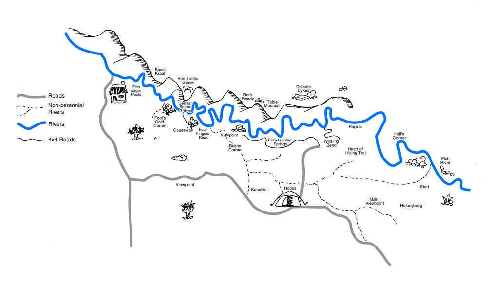
Fish River Trail map
The Fish River hiking trail is particularly unique because in the beginning it is very difficult, but it becomes easier as you go, coming to an almost boring end.
This might sound silly, but make sure your toenails are trimmed. Many hikers loose a toenail or two because of the constant breaking and restraining of going downhill. Remember to stop and look around often to admire the different geological layers and levels, shaped through the weather and erosion of many millions of years. The white sand and sparkling water of the first deep rock pool at the bottom is a well-deserved reward for those jittery legs and muscles that are just starting to ache. Swimming or just sitting in the cool water is a great relief for all kinds of aches and pains!
With the most difficult part of the hike behind you, some challenging sections still lie ahead. Don’t be in a hurry to carry on. This first section is also the most beautiful part of the canyon, narrow between high cliffs and the imposing, polished boulders. The biggest challenge is to navigate successfully on the marked trails over the big boulders while carrying a heavy backpack, especially when the water levels are high after a good rainy season.
By the second day, if all goes according to plan, the Sulphur Springs come as a welcome surprise to many tired hikers. Palm trees with a stream of steaming hot water running down the cliffs – very much like a much-awaited oasis. The sulphur smell can be a bit overwhelming, but don’t let that keep you from enjoying the soothing warm water. An even better option is to watch the stars during a late night session in these natural baths. If the water level is high in a particular season, don’t be surprised it you cannot even get to the springs from the other side of the stream.
Untouched wilderness
After the Sulphur Springs, the strenuous stretches become more frequent and longer. Three challenges are ever-present: where and how to cross the river, and how to avoid taking off and putting hiking boots back on again. That is to say if it is possible to cross the stream at all! During some good rainy seasons the water level can be so high at the beginning of the hiking season that it is easier to ‘hike’ on an inflated tube than navigating the rocks. A hiking stick is always a good travel companion and will come in handy, especially when crossing the river. Be it the ever-increasing thick sand and powdery dust, especially during the dryer months, or jumping from one round stone to the next trying not to slip, or wading through the brown water, ‘feeling’ your way – the result is increasingly aching muscles as the end of the trail approaches.
Enjoy every moment of untouched wilderness, as by the fourth or fifth day the canyon becomes wider and the sudden signs of civilisation (at Ai-Ais) might come as a shock. Gone are the peace and quiet, the klipspringers and baboons, and the cool refreshing water of the rock pools with their indescribable reflections. The Fish River Hike is one of those hikes that every person must experience at least once in their lifetimes.
Groups may not be not less than three and more than 30 hikers. Bookings, permits and medical forms are available at Namibia Wildlife Resorts (NWR) offices or can be downloaded from their website (www.nwr.com.na) and be handed in at the checkpoint at Hobas.
This article appeared in the Aug/Sep ‘09 edition of Travel News Namibia.