
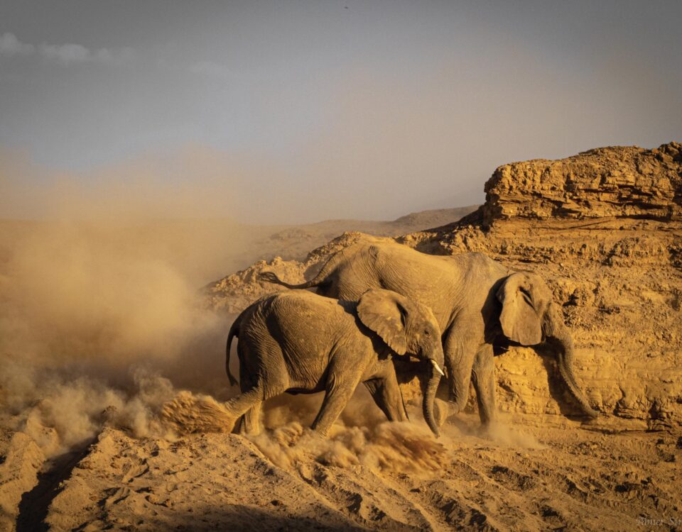
Human and elephant conflict a major difficulty in conservation
July 5, 2012Custodianship programme: Black Rhino realities
July 5, 2012By Chris Brown and Jo Tagg
Every farmer knows how many head of livestock he has. He knows where they are, and he knows how they have bred and increased or decreased in numbers over the past few years. This is the bare essential information needed to manage a livestock operation. Of course, there is a lot of additional information that is also needed, such as rainfall and range condition, market prices and many others.
If your business is not in livestock but in wildlife, you need the same sets of information. The only difference is that the animals you are dealing with are a lot less co-operative. They don’t walk into the kraal at night to be counted and they cannot be herded from one paddock to another. They probably don’t even stay on your land all year. So perhaps you have a shared resource and not exclusive ownership.
When Africa was one huge open paradise with no farms and no fences, the wildlife was free to move to wherever water and grazing was most abundant. Animal numbers and diversity changed on an almost continuous basis in response to seasons, climatic conditions, presence of predators and many other factors. Nowhere was this more dynamic than in the arid and semi-arid deserts and savannahs of Southern Africa. Vast herds of buffalo, wildebeest, plains zebra, eland, hartebeest, gemsbok, springbok and many other species swept over the plains in their thousands and hundreds of thousands. The great springbok migrations of the 19th century are legendary. Animals covered huge distances in response to rainfall, moving in circular fashion over huge areas.
The early explorers and traders with their guns acted as if wildlife were an infinite resource traded guns for livestock. By the start of the 19th century elephants had been shot out of southern Namibia, and many of the other species were starting to decline. Giraffe disappeared from the south some 50 years later. Then came a new breed of farmers. Nomadic farming practices that were gentle and adapted to arid and semi-arid environmental conditions were replaced by fixed farming and fences. Pressure was placed on rangelands throughout the year and they declined in productivity. Wildlife was seen as food, skins and competition for grazing. Fences cut off the nomadic and migration routes and many species of wildlife could no longer move freely in response to changing climatic conditions. Their numbers declined still further. The penultimate atrocity was introduced via the veterinary profession, which enforced programmes to eliminate buffalo and wildebeest from farming areas, essentially replacing indigenous grazers that were well adapted to arid and semi-arid conditions with exotic domestic stock imported from Europe and elsewhere. After a century of fighting the environment, battling through drought years, poisoning the predators and carelessly eliminating the scavengers, and shooting the wildlife in a desperate battle to survive in the harsh and unforgiving drylands, they reached a stage where the land had lost much of its productivity. Bush encroachment covered millions of hectares, perennial grasses had been largely replaced by annuals, water tables were declining and farmlands now supported only half the livestock it had in the early years.
A radical policy-reform process is now changing the face of Namibia. Some 30 years ago freehold farmers were given conditional rights over common wildlife species. This same reform was extended to the communal areas in 1996. The incentives created through policy-reform processes like these now make wildlife and its associated industries a more profitable form of land use over much of Namibia. This, in turn, is leading to a change in land use, from farming to wildlife and tourism – essentially land use based on indigenous biodiversity, natural habitats and unspoiled landscapes. The conservation value of this change in land use, particularly on fragile dryland systems, is obvious. Less obvious are the positive economic impacts. It creates far greater economic returns per hectare than does farming, it created many more jobs, it creates more small-enterprise opportunities and it offers far greater potential for training and capacity-building.
As the local and national economies of Namibia shift towards wildlife, so it becomes more important for managers and regulators to know more about the resource being managed. The question arises of how to best monitor wildlife numbers and trends in cost-effective ways. There are many census methods. Some involve aerial survey techniques and counting wildlife from an aircraft, others involve catching, marking and releasing animals and then determining the proportion of marked animals to unmarked ones in a population, and thus calculating the total population. Yet other methods involve counting animals at waterholes in the dry season over periods of 48 hours or longer. These are just a few of the more commonly used approaches. All these methods have advantages and disadvantages, depending on the species and conditions in the area. For example, some species, such as springbok, are extremely difficult to see from the air, even on open gravel plains. Other species don’t need to drink every day or even every week. Some methods are expensive and others are time-consuming.
In the more open and arid areas of Namibia, one method for counting the plains game is proving to be particularly effective. This is the Fixed Route Road Count method. It is cost-effective, efficient and easily repeatable. Today it is being applied to some seven million hectares of land in communal conservancies, freehold conservancies, private nature reserves and national parks. The method is applied uniformly across all these areas, not just for consistency from year to year, but also for spatial consistency, so that wildlife trends across the landscape can be compared.
In the same way that farmers need basic information about the livestock, there are three main reasons for counting wildlife: the first is to determine trends over time, so that we know whether species are increasing, decreasing or remaining fairly stable. The second is to determine approximate population sizes, so that we can calculate the numbers of animals and their biomass per area of land. Together with the rainfall and vegetation conditions, the wildlife numbers and biomass help us evaluate carrying capacity for a particular year and decide whether an area is overstocked or is able to carry that many animals through the season.
One of the major differences between arid and higher rainfall areas is that, in high rainfall belts, carrying capacity is fairly constant from year to year, whereas in arid and semi-arid zones, carrying capacity may vary hugely from year to year. The veld’s carrying capacity is thus unpredictable. Also, when and how the rain falls is a critical factor. One huge storm of 40 mm over two hours doesn’t have nearly as beneficial an effect on the vegetation as a week of cloudy weather with the same amount of rain falling slowly and gently over a few days.
The third reason for counting wildlife is to determine distribution – where are the animals? This is once again normally linked to the growth of vegetation, which is linked to rainfall. Not only is rainfall highly variable and unpredictable from year to year, but also spatially over the landscape. It is all too common for one area to receive 25 mm during a rainfall event while just 2 km away only 5 mm of rain falls. As a result, animals move over large areas. Because numbers decline in one area does not necessarily mean that the population has declined. It is more likely that the animals have moved. Monitoring large areas is most important to fully understand what is happening to the wildlife resource.
For the purpose of Fixed Route Counts, the area to be counted is usually divided into manageable-sized landscape categories. These may include gravel and sandy plains, incised rocky terrain, broken granite outcrops, ephemeral river courses, and so on. Routes are carefully selected through each of these landscapes, with a sample intensity of about 300–500 hectares per kilometre of road surveyed. These routes are standardised as much as possible, to ensure that changes detected from count to count are a result of wildlife abundance changes, and not because of different methods used. This means that exactly the same route, travelling in the same direction and with the same speed, with the same type of vehicle, starting at the same time, applying the same rules and recording all observations on standardised forms, are carried out in the same month of each year. Typically teams of 4-6 people, familiar with the specific route, carry out the counts, starting early in the morning while conditions are cool and visibility is good.
The teams start their counts at the precise time set for each route. As they travel along their route, they record each animal sighted, the species, numbers and age classes. They record the distance of the animal(s) from the road and record the exact location on a grid map. The information on the distance of each sighting from the road is used to calculate correction factors for each species. Fewer animals are observed at 400 m from the road than at 50 m. Also, some species are easier to see than others – giraffe for example, compared to steenbok.
At the end of each count, the teams gather to tally up the numbers for each species they have seen and to compare notes. These are then checked and entered into a spreadsheet. The spreadsheet automatically calculates the numbers of each species seen per 100 km travelled, to give us trend information. It produces distribution maps and applies the necessary correction factors to give population estimates. The results of the game count are then discussed and hotly debated, as the counters try and understand the changes that have taken place and what has caused them.
This article appeared in the 2005/6 edition of Conservation and the Environment in Namibia.